Ill. Admin. Code tit. 35, § 618.APPENDIX B
Boundaries of Fayette Water Company's Maximum Setback Zone
Effective Jun 27, 201236 Ill. Reg. 10042AUTHORITY: Implementing Section 14.3 and authorized by Section 27 of the Illinois Environmental Protection Act [415 ILCS 5/14.3 and 27].POLLUTION CONTROL BOARD
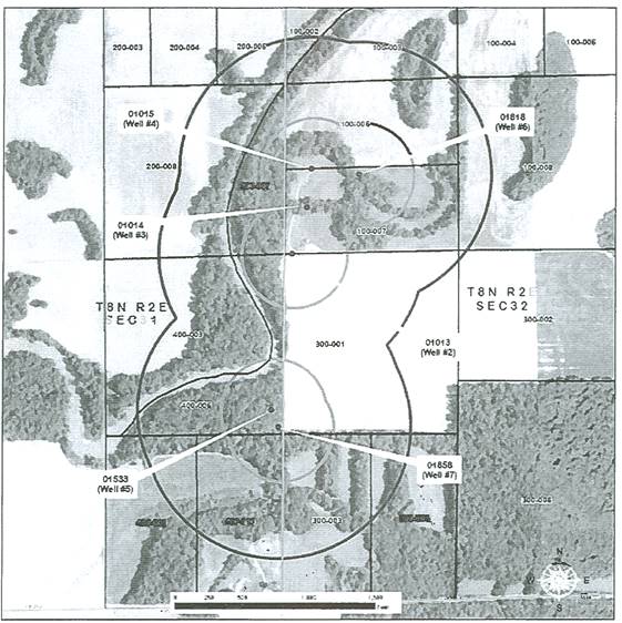
| MAXIMUM SETBACK ZONE FAYETTE WATER COMPANY (IL0510010) T8N R2E 3rd PRINCIPAL MERIDIAN | ||||
| SECTION 31 | ||||
| Partially Contained | Wholly Contained | |||
| 200 - 004 | 400 - 008 | |||
| 200 - 005 | ||||
| 200 - 008 | ||||
| 400 - 003 | ||||
| 400 - 006 | ||||
| 400 - 008 | ||||
| 400 - 009 | ||||
| 400 - 010 | ||||
| SECTION 32 | ||||
| Partially Contained | Wholly Contained | |||
| 100 - 002 | 100 - 007 | |||
| 100 - 003 | ||||
| 100 - 006 | ||||
| 100 - 008 | ||||
| 300 - 001 | ||||
| 300 - 002 | ||||
| 300 - 003 | ||||
| 300 - 004 | ||||
| Legend | ||||
| • | Community Water Supply Wells | |||
 | CWS Wells Minimum Setback Zone | |||
| Proposed Maximum Setback Zone | ||||
| Fayette County PINS | ||||
| Section Boundaries | ||||
SOURCE INFORMATION
Fayette County PINS obtained from the Fayette County Assessor's Office. Aerial photography obtained from Microsoft's Virtual Earth. Minimum and Maximum Setback zones, and CWS wells maintained by, and map compiled and created by the Illinois EPA, Division of Water Supplies, Groundwater Section.
(Source: Added at 36 Ill. Reg. 10042, effective June 27, 2012)